Report: The 12 Most Dangerous Areas For Cyclists & Pedestrians In NYC
Aug. 8, 2018, 2:44 p.m.
The report spotlights a dozen neighborhoods where pedestrians and cyclists are three times more likely to be injured or killed in a crash.
Localize.city, a website that analyzes data about New York City addresses, released a new report today highlighting the 12 most dangerous areas for pedestrians and cyclists—neighborhoods where they are three times more likely to be injured or killed in a crash than other areas.
The analysis found that throughout the city, crashes are more likely to occur around elevated tracks or bridges, and their approaches, in areas where sight lines might be blocked. Analyzing data from January 2013 to January 2018, Localize.city isolated a dozen areas with an average of 238 crashes, compared to an average of 75 in the rest of the city.
“Around major bridges in New York City, you have heavy vehicle, bike, and pedestrian traffic all cramming into a narrow corridor, increasing the risk of crashes. This is exacerbated in places like Williamsburg and the Lower East Side, where many vehicles find their way to the bridge through busy residential neighborhoods,” Localize.city urban planner Andrew Lassiter said in the report. “And in neighborhoods with elevated subway or LIRR tracks, the streets below the tracks can be pretty chaotic. Visibility is tough with so many support posts, and the layout of the street can make drivers’ actions unpredictable.”
Using city crash stats, data analysts compared the number of crashes against an index "that weighted one-, two- and multi-lane streets differently to avoid a bias toward streets with more traffic," the report's authors explain. Further:
To devise the most dangerous intersections by one-, two- and three-lanes by borough, the data scientists filtered the locations by looking at junctions where the number of crashes involving pedestrians or cyclists (using NYPD motor vehicle collisions data) that were above the 99.5 percentile in their category between 2013 to 2017, and between 2015 to 2017.
More than half of the causes of the crash were unspecified in police reports. The data Localize.city used does not specify the severity of the collisions or injuries.
“We know how to prevent death and serious injury on our streets, and with this study, we also have a better understanding of where the City should target investments in safer street redesigns,” said Paul Steely White, executive director of Transportation Alternatives, in the report. “Traffic deaths are falling in New York thanks to the City’s data-driven approach to street safety. Thanks to this critical research, we can further reduce the threat to pedestrians and bicyclists at the intersections where help is needed most.”
A 2017 study by the NYC Health Department revealed adults 65 and older, which represent only 13 percent of the city population, had the highest rate of pedestrian fatality, at 37 percent. Brooklyn had the highest rate of pedestrian fatalities among older adults, and children and older adults were more likely to be struck within 10 blocks of home. The report also gives a profile of the drivers involved in fatal pedestrian accidents. 83 percent are male and 30 percent were 18-34 years old.
A spokesperson for the New York City Department of Transportation told Gothamist in an email that the DOT will review the report, and that the Vision Zero Borough Pedestrian Safety Action Plans identify priority corridors, intersections, and areas throughout New York City. When asked about how the DOT will address pedestrian and cyclist safety around the Williamsburg Bridge, with the impending L train shutdown, the DOT spokesperson said "last summer, DOT improved access to and from the Brooklyn entrance of the Williamsburg Bridge bike path and improved connections from the bridge to East Williamsburg and Bushwick. The project included improved bike access to the Williamsburg Bridge Bike Path and pedestrian access to each side of Borinquen Place where the Brooklyn - Queens Expressway and Williamsburg Bridge structure separates the neighborhood. It also enhanced bicycle connections to and from the Williamsburg Bridge from the east by proposing new bike routes to East Williamsburg and Bushwick."
Here are the 12 most dangerous areas for pedestrians and cyclists, according to Localize.city:
Brooklyn
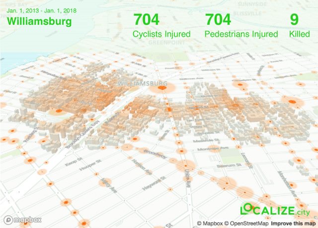
Williamsburg: general boundaries between Lee Avenue and North Seventh/Metropolitan Avenue, from Berry Street to Bushwick Avenue
Downtown Brooklyn: general boundaries between Atlantic Avenue and Willoughby Street, from Boerum Place and Bond Street
Crown Heights/Bedford-Stuyvesant: general boundaries between Pacific and Fulton streets, from Bedford to Brooklyn avenues
Bronx
Fordham/University Heights: general boundaries between Aqueduct Avenue and Ryer Avenue, from West Fordham Road and West Tremont Avenue
Manhattan
Lower East Side/Little Italy/Soho: concentrated around Delancey/Kenmare Street. General boundaries between Spring and Grand streets, from Broadway to Forsyth Street
Queens
Corona: general boundaries between 35th and Roosevelt Avenues, from 94th to 108th streets
Jackson Heights: general boundaries between 37th Avenue and Broadway, from 76th Street to 84th Street/Whitney Avenue
Flushing: general boundaries between College Point Avenue and Parsons Boulevard, from 37th to Franklin avenues
Ridgewood: general boundaries between Woodward and Myrtle avenues, from Grove Street to Forest Avenue
Jamaica: general boundaries between 89th to 90th avenues, from 164th Street to 168th Place
Staten Island
St. George/Tompkinsville: general boundaries from Jersey to Bay streets, between Victory Boulevard to Fort Place/Taft Avenue
Stapleton: general boundaries between Bay and Van Duzer streets, from Wright to Tompkins streets