As Sea Levels Rise, De Blasio Unveils $10 Billion Plan To Expand Lower Manhattan
March 14, 2019, 1:11 p.m.
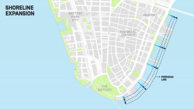
The city has confirmed a plan to expand the edge of Lower Manhattan into the East River, creating approximately 500 feet of new land on the waterfront between the Brooklyn Bridge and the Battery.
Two city blocks of proposed infill
Mayor Bill de Blasio confirmed today that he is planning to expand the edge of Lower Manhattan into the East River, creating approximately 500 feet of new land on the waterfront between the Brooklyn Bridge and the Battery at a cost of approximately $10 billion.
The proposal, which Gothamist first reported last week, is aimed at protecting the low-lying Financial District and South Street Seaport area from the next Hurricane Sandy-level storm as well as ongoing sea level rise, according to the Mayor's Office. The massive undertaking would most likely be paid for through a public-private partnership, paving the way for unspecified development on a new land mass expected to extend the equivalent of two city blocks into the river.
News of the plan immediately evoked comparisons to the Bloomberg-era idea of building a counterpart to Battery Park City on the east side, to be known as Seaport City. Gotham Unbound author and environmental historian Ted Steinberg said the idea "sounds like Seaport City. New wine in an old bottle, so to speak."
Additional details of the de Blasio administration's proposal were unveiled during a press conference on Thursday morning accompanying the city-run Economic Development Corporation's release of its Lower Manhattan Coastal Resilience Study. The survey projected that, as a result of climate change, 37 percent of properties in Lower Manhattan will be at risk of storm surge by 2050, and a significant chunk of the area will be exposed to daily tidal inundation by the end of the century.

(via EDC)
With that in mind, the city has embarked on a multi-pronged effort to fortify the borough's lower segment, investing $500 million toward flood protection initiatives like raising the wharf in Battery Park City and developing flip-up barriers for Two Bridges. Construction on those projects is set to begin in 2021, and temporary HESCO barriers will be put in place ahead of the next hurricane season, according to city officials.
But the vulnerable coastline between Brooklyn Bridge and the Battery is a special case. According to the de Blasio administration, the low-lying topography and the subterranean tangle of highway tunnels, subway lines, utilities, and sewers leaves the city no choice but to build outward — at a tremendous cost, and with no current funding source identified.

(via EDC)
"We recognize that building in the water will be challenging and we're treating this option as the absolute last resort," said EDC president James Patchett. "But our analysis has shown that an on-land solution...is just not viable in this segment of original Seaport City area."
Asked about how this multi-billion-dollar land extension would be paid for, and what sort of structures would sit on top of it, de Blasio said those questions were still being considered, and might not be worked out for at least a few years.
"This is where the federal question really comes into play," the mayor told reporters. "If something like a Green New Deal moves forward...that would mean a huge amount of federal funding."
And if it doesn't?
"From the perspective of the city of New York alone, this would be extraordinary difficult to fund," he added. "If there's federal money in play, it probably looks one way. If there's not federal money at play, we have to get some private money into it, so then there has to be some development."
UPDATE 4:15 p.m.: Responses to de Blasio's announcement are beginning to trickle in, with some local officials and advocacy groups voicing immediate concerns about the proposal.
On Twitter, Councilmember Francisco Moya, whose district includes the East Elmhurst waterfront, took exception to the mayor's categorization of Lower Manhattan as the area of the city most threatened by climate change, and seemed to suggest that the plan would come at the expense of other flood-prone neighborhoods throughout the five boroughs.
The mayor says “Nowhere is that threat” of #climatechange flooding greater than in lower Manhattan.
Yeah... no. Here’s just what my district would look like if sea levels rose 0-8 ft.
See also #LIC #BroadChannel Southern #Queens #RedHook #ConeyIsland #BrightonBeach. C’mon. pic.twitter.com/UED9KFiOUD— Francisco Moya (@FranciscoMoyaNY) March 14, 2019
The Waterfront Alliance commended the mayor for “thinking big,” while also listing a range of questions about the proposal that they want answered. Among their concerns is that the project could take decades to complete due to litigation and regulatory reviews, that there has not been a more transparent cost benefit analysis, and that equally vulnerable neighborhoods like Red Hook and Hunts Point have not received the same attention.
“All options should be on the table, but we need to have a full understanding of the trade-offs,” said Roland Lewis, President and CEO of the Waterfront Alliance.
Meanwhile, Riverkeeper Senior Attorney Mike Dulong warned that the new development would “bury East River fish.”
“It’s up to us to build upon the legacy of great environmentalists like Bob Boyle and protect these waters and their fish from bad development proposals, like Seaport City and Westway,” wrote Dulong on the advocacy group’s website.